 {width=500}
ODK Collect has recently gained the ability to load an external data file in GeoJson format of existing data. It’s then possible to select existing data and then import it’s values into the XForm as default values. This lets the mapper use the XForm to change the existing data, or add to it. Any changes will need to be conflated later, that’ll be another document.
Why do I want to use ODK Collect to edit map data ? Much of what is currently in OpenStreetMap is lacking metadata, or the data has changed, like when a restaurant changes owners and gets a new name. Also most all remote mapping using satellite imagery lacks tags beyond building=yes. When we are doing a ground data collection project, we want to add useful tags like the building material, or whether it’s a cafe or a hospital.
Old imports also bring in problems, for example the infamous TIGER import. Mappers have been cleaning that mess up for over a decade. But an old import may have a weird value for an OSM tag, and it’s usually better to update to a more community approved data model. The beauty and the curse of OSM data is it’s wonderful flexibility. People do invent new tags for a specific mapping campaign or import that escape being reviewed. And there are also typographical mistakes, weird capitalization, embedded quote marks, all sorts of weird values worth correcting.
While there are a multitude of places to get data from, since I’m using OSM data, I can either download a database dump from GeoFabrik, and use that as a flat file or import it into a database. Or use Overpass Turbo. I prefer using the datafile from GeoFabrik, and importing it into a database.
There is a translation between the column names one gets when querying the data and how ODK Collect sees it. There is the following translation from ODK to OSM as well, and they all have to work together for a clean data flow. I like to keep all the tag and values as similar as possible, cause otherwise it’s easy to get lost. The rough rule of thumb is to make sure that all names are unique. As I’m using ogr2ogr to do data extracts from a postgres database, I have a little more control than when using Overpass. Plus I can process much larger datasets than Overpass can.
For my database SQL queries, I use the AS keyword to redefine the output column name, so I can use the OSM standard name in the survey and choices sheets. That makes the next translation step much cleaner. I try to be consistent so it’s easier to follow the data flow. My currrent technique is to append an x to the end of each column, so healthcare becomes healthcarex.
Then in the XLSForm, I can use healthcarex for the instance, and then I’ll use xhealthcare as the value for the calculation column in the survey sheet. Then the value in the name column of the survey sheet is just healthcare, as that’ll translate directly into it’s OSM tag equivalant.
If use use a text type in your XLSForm, you can support most any weird value. But as we are aiming for tag validation and tag completeness, we prefer to have an approved value. If using a data model, the the list of choices for a tag is defined. Anything outside of that is not part of the data model, and will cause an error. That’s documented later in this doc. Currently unless you are very careful with what columns you return from the SQL query, you will get XPATH erros in ODK Collect.
Currently if a weird value is found in the data extract that continues to break ODK Collect, it must be removed. In that case it must be manually edited, and the weird values changed or deleted. At some point I may write a filter program that uses the data model as defined in a YAML file, but I’m not there yet.
Debugging complex interactions between the XLSForm, my external data files, and ODK Collect often has left me scratching my head more than once. Here’s a few tricks to help debug what is going on.
Most of the time when using external data you have the map value in the appearance column of the survey sheet. That’s how we want to use it in the field. But it slows down the repetitious process of debugging everything. I turn off map values, and then I just have the select menu, which is more efficient. That works especially well if you have a small data file for testing, because then it’s easy to cycle between them.
To use the placement map, here’s an example.
| type | name | label | appearance |
|---|---|---|---|
| select_one_from_file camp_sites.geojson | existing | Existing Campsites | map |
And an example were there values in the data file are an inline select menu instead.
| type | name | label | appearance |
|---|---|---|---|
| select_one_from_file camp_sites.geojson | existing | Existing Campsites | minimal |
Often the bug you are trying to find is obscure, you just don’t see any of the data file values being propogated into ODK Collect, when that was working previously. In that case I just add a text survey question, whose entire purpose is to display any of the values
| type | name | label | calculation | trigger |
|---|---|---|---|---|
| calculate | xid | OSM ID | instance(“camp_sites”)/root/item[id=${existing}]/id| |calculate|xlabel|Get the label|instance(“camp_sites”)/root/item[id=${existing}]/title | |
| calculate | xref | Reference number | instance(“camp_sites”)/root/item[id=${existing}]/ref|| |calculate|xlocation|Location|instance(“camp_sites”)/root/item[id=${existing}]/geometry | |
| calculate | xtourism | camping type | instance(“camp_sites”)/root/item[id=${existing}]/tourism|| |calculate|xleisure|leisure type|instance(“camp_sites”)/root/item[id=${existing}]/leisure | |
| text | debug1 | Leisure | xleisure|{existing} | |
| text | debug2 | OSM ID | xid|{existing} | |
| text | debug3 | Ref number | xref|{existing} | |
| text | debug4 | Tourism | xtourism|{existing} |
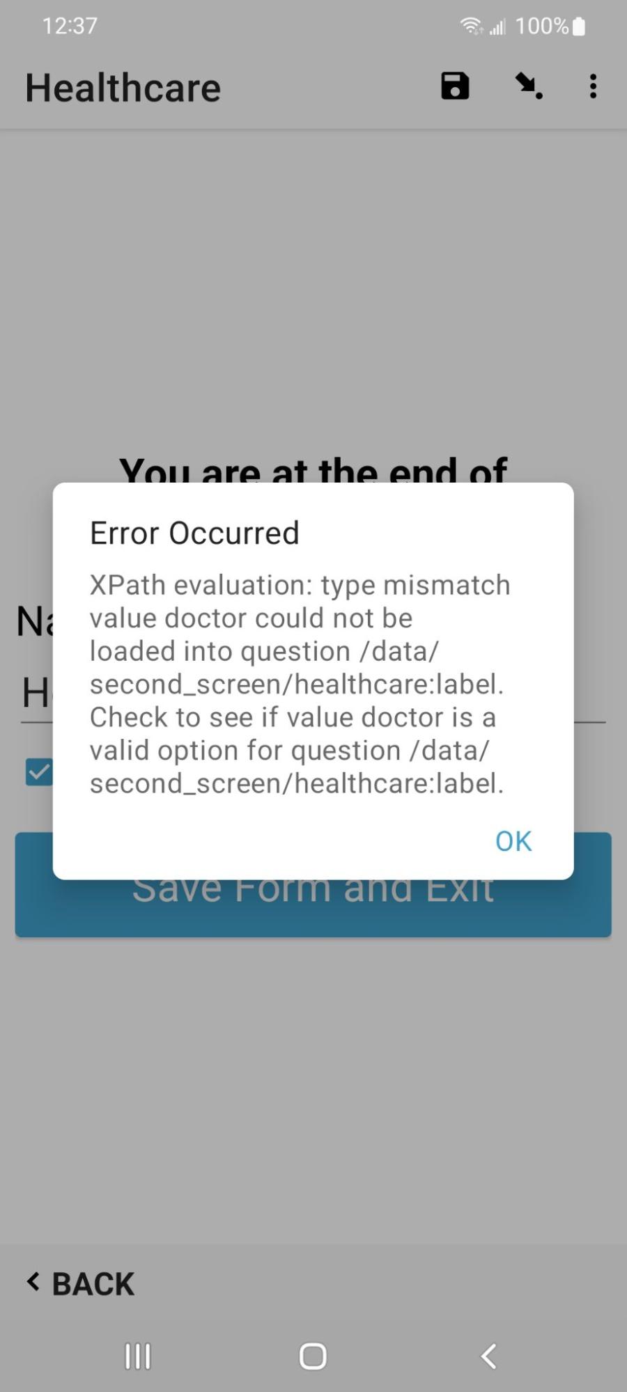
Assuming xls2xform is happy, sometimes you get this error message in ODK Collect when switching screens. You’ll see this when you have a value in your data file for a select_one survey question, but that value not in the list of values in the choices sheet for that tag. In this example, there is no doctor value in the healthcare selection in the choices sheet.
{width=500}