Trip Preparations
Before heading off on a field mapping trip, I usually do a fair bit of research long before leaving. I’ve been working on improving the map data for Colorado for years, ground-truthing existing data, and adding features based on my own field trips. Since I’m focused on the rural parts of my state, this means camping every night, and working primarily offline. Also driving on lots of really bad roads.
To start, I try to think of areas I haven’t spent much time in, in the past often just driving through without stopping. How I work offline is another document, as well as the tech details of data collection. This type of trip is very explorative, so to start I try to identify a few areas, one per day, for each day of the trip. And also to have backup plans, since reality can be very different than the map,
I start by spending time going over existing data, often using JOSM. I can display current OSM data on top of satellite imagery to get some sense of data completeness. If there are a few buildings in OSM, but plenty are visible in the imagery in what looks to be a small business “downtown”, that becomes a waypoint. Also many of these small towns have had businesses closing or changing names during the pandemic.
To set a waypoint for a desired target location, I use JOSM. I just create a node with some custom tags. This data, the target locations for data collection, aren’t ever going to be uploaded to OSM, just the data collected there later. For a town, I’ll usually just add a name tag and place= tag. Once I’ve identified the daily mapping locations, in JOSM I just export the layer as a GPX file. This GPX file will get used elsewhere for navigation.
In addition to the amenity mapping along remote rural highways, I also research and identify possible camping spots. Since much of my state is BLM or USFS owned, both public land, people can camp most anywhere something suitable exists. There are many remote camping areas, most not on any map. Since I’m also updating road data in OSM, I’m often way up a jeep track, so might as well camp and enjoy a “work” trip.
I’ve done enough of this type of solo field mapping trips to have a good idea about how much time everything takes. I try to plan to end each day at a good campsite. Since I’m talking about remote, distributed and unofficial campsites. They are all over public lands in the US West, and can legally be camped for free for 14 days. Most aren’t documented anywhere. I use satellite imagery and USGS topographic basemaps, switching between them to evaluate a possible camp. There are also many free Bureau of Land Management (BLM) and US Forest Service (USFS) campgrounds. Most of those aren’t much more than a parking lot that’s designated for camping. These are also often not on any map other than the ones published by those agencies.
Often the reality on the ground is very different from how it looks in satellite imagery. I make sure to have multiple options as often when you get there you realize it’s not good camping, so off to the next idea. In many remote areas, most any dirt track has short spurs off the main track that lead to campsites. A good indication is you can see the spur road on imagery, but it’s not in the USGS topographical map. With decent enough imagery, you can often actually see tents, RVs, firepits, etc… which is a good sign. Even public lands are full of private inholdings, so that’s not a guarantee you can camp there. And often they’re popular, so may already be occupied.
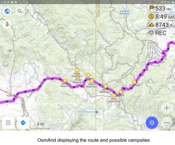
I’ll use JOSM to make a node for each possible camping spot, and then export that as a GPX file. That gets loaded into OsmAnd running on a tablet in my truck cab. Each camping spot gets an icon in the display, and I can see them all while driving down the road. And use them for navigation.
To create a route to connect all my target locations, these days I use a desktop tool called Offroad. Offroad is a port of OsmAnd to the desktop. The cool part is I can load in the GPX file I just created of target locations and camping spots, and view them all on the map. Offroad does routing, so I can select my starting point (home), and intermediate points at each target location, and then generate a route. Important details like road distance between gas stations, and important planning details. One must never try to drive further than you have gas for. I usually top off at every obscure and remote gas station I find. So I’ll experiment with different routes. I’m willing to drive a little out of my way for something interesting.
Offroad then lets me export the route, also as a GPX file. This GPX file I then use for navigation. Usually I adjust the route and locations for a few days as I research the road conditions and other details. Like what appears to be good camping, is probably private land. Or the road into a good camping spot is on a pretty borderline jeep track. I’m usually checking OSM and other sources on the road conditions. Just cause it’s got a county reference number, doesn’t mean it’s drivable by all vehicles.
Offroad also works offline, so I can make adjustments while offline. I wouldn’t do that for minor changes, but sometimes roads are closed, the weather is bad for days, etc… Anyway, I export the final GPX file for navigation.
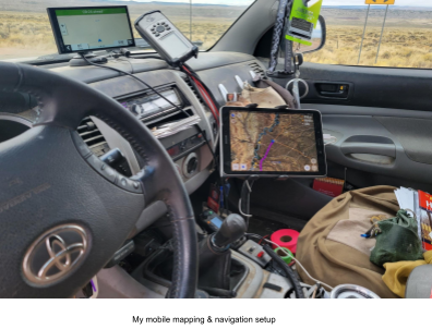
For navigation I primarily use OsmAnd, as it works well offline. In my truck I also have a Garmin GPS, so I often compare route suggestions. At least in remote areas, OsmAnd works much better than my Garmin as often the data is deeper. Not always though, and getting stuck on a bad road in the middle of no place is no fun. I can load both the camping and amenity GPX files as favorites, and then the route as a track. It’s also possible to load the GPX files of the locations into a Garmin.
You can display the route in OsmAnd with navigation. It’ll be a thick purple line on all the highways. You can just display the route as you drive and make sure you’re on track and it’ll use less battery power than full navigation. To navigate a track, under the Navigation menu item, click on Options, and then Navigate Track. You can turn on navigation at any time while displaying the track. OsmAnd also supports audio prompts for turn by turn directions if you are navigating. The possible camping spots also are on the map, so I can see where I am in relation, or use them as a navigation destination.
The tricky part of navigating in remote areas is often the existing data isn’t very good. You may be up a dirt track, turn onto another track, then another, etc… Sometimes the road on the map looks fine, until suddenly it’s not anymore. Course where road conditions change is a data collection task, which is the whole point of the trip. Many times the primary dirt track is ok for all vehicles, but all the side spurs require high-clearance vehicles. But it isn’t much fun if you have to make a really long detour because the road data wasn’t complete. Highways added by tracing satellite imagery are lacking tags other than highway=*. Ground truthing adds the important OSM tags for navigation, surface, smoothness, tracktype, width. Those are all used in the routing algorithm, and also display differently in OsmAnd. When I add those highway tags to OSM, navigation works better.
I’m usually comparing a high-end Garmin GPS, sometimes Google Maps, with OSM. Especially in remote areas, at least with OsmAnd and OrganicMaps, the routing avoids the really bad tracks, and sticks to the more maintained roads. My Garmin and Google Maps often want me to drive down a supposed road that is really only suitable for an off road vehicle, like a UTV. There are parts of Colorado where there are billboards that say “Don’t trust your GPS ! You’ll get stuck on a jeep trail!”. OSM offline routing worked much better in that area.
When planning on mapping offline, it’s good to make custom basemaps for both OsmAnd and OdkCollect. The whole point is data collection (and good camping), and basemaps are very useful. I usually take both satellite imagery and USGS topographical maps as my primary basemaps. I produce large scale maps at a lower resolution, and smaller high resolution maps of areas of focus.
The lower resolution basemaps I use on my navigation tablet, which runs OsmAnd. That’s what gets used mostly while driving. I switch between satellite imagery and USGS topo maps depending on what I’m doing. When in the area I want to do data collection in, I switch to the higher resolution basemaps. Yes, only buy mobile devices with lots of storage, or an ability to remove and add maps from a laptop as you change areas.
I use MobileAtlas to make basemaps, as it supports both sqlitedb for OsmAnd and mbtilles for ODK Collect and other apps. I’ve usually preloaded both satellite imagery and USGS topo map data on my primary desktop, so mostly MobileAtlas is just producing the output files. Downloading all the tiles to do this may take weeks, so better to plan ahead and start caching basemap tiles of your favorite sources.
Satellite basemaps are especially useful when looking for primitive camping. That nice dirt road you see may be somebody’s driveway. If you have local imagery available on your mobile device, you can look to see if there are buildings. Not all buildings are in OSM yet.
Often for a trip like this into a remote area, I load up my laptop and mapping devices with a few extra files. When planning to be offline for days in an area with sparse map data, you never know what you will need. Although I can camp most anywhere on public land (with local restrictions), public land is often full of private land, and often it’s where you think would be good camping… People with guns or law enforcement may interrupt your camping if you get this wrong… This mistake is usually handled by moving to another location, which you hope is ok with the locals. I’ve taken to wearing my wildland fire fighting clothes, it helps support why I’m there. I also ask the locals where I can camp, and all is good.
So I carry parcel ownership data, when I can get it. This becomes an overlay in OsmAnd, since parcel data shouldn’t be in OSM. But this lets me see if it’s public or private, as often the map data isn’t clear.I use the parcel data as well when picking the target locations and camping spots. I also have some other data files that one of these days I’ll do an import… but till then I just carry the raw data with me. This is usually government generated data, state park campgrounds, highway classifications in the national forest, etc. Mostly that is to support the weird navigation problems when you want to make an informed decision on the spot, and of course there is no cell connection, so carry the extra data.